
41 infrastructure
on site review 41: infrastructure
Infrastructure: underpinning structure that makes the more ephemeral aspects of life work. Roads and roadbeds, compacted scree, drainage channels and concrete bumpers painted fluorescent yellow — these infrastructural elements allow us to drive to Banff and look at the mountains. Dams, electricity pylons, docks, railway lines, fibre-optic cable, batteries: acid, lithium and all the rest. Airports, bridges, household wiring. All these things are permanent, essential, vulnerable, either crumbling or overbuilt, ancient or experimental.
In an era of great upheaval, where normality is a figment of rosy memory, where climate is forever changed, where pandemic viruses become as common as the cold, where the rich get richer and the rest get poorer, what is it that we ask of infrastructure?
Is infrastructure a stabilising element, or is it a force with agency? China’s Belt and Road Initiative is changing Asia and Africa; the disrepair of North America’s highway infrastructure contributes to problems with transport: pipelines full of oil battle with trains dragging hundreds of tank cars across the country and tanker trailers dangerously share the highways with private automobiles.
Infrastructure is hidden, taken for granted until it breaks and then we are all surprised.
What is it? and as designers, what is our relationship to it? Is it the purview of civil engineers and political promises, or is architecture the translation of infrastructure to the operation of daily life?
Is the public realm actually infrastructure, in all its depth and function?
And now, in the 2020s, what is exciting about infrastructure? American politics have included the social safety net as the infrastructure of society, in a stroke shifting infrastructure from physical and material construction to something infinitely more ambiguous and algae-like: the socio-economic political functioning of society.
For this issue, we would like to look at infrastructure: the landscapes of infrastructure, infrastructural networks, how parts fit together, how they service life on this planet.
How these installations affect society, often seen most clearly in their absence, such as clean drinking water, is how we critique infrastructure. What is the Belt and Road, and what will be its environmental, social, political, military and economic consequences? Much has been written about the consequences of the Interstate Highway system in the USA, on its military reasoning, its demand for faster and larger vehicles, its social anonymity that bolsters a particularly American notion of personal freedom. These things were latent in the maps and road sections of the IH system.
What is it that is latent in the trillions of dollars being spent on infrastructure today?
There are other infras: Perec’s infra-ordinary, where space is both invention and inventory; Duchamp’s inframince, the unmeasurable thinness between things that touch, between one state and another; infra dignitatem: beneath notice, something so uncool that one cannot look at it, something like traditional infrastructure to the discipline of architecture.
Which is why we would like to look at it now.
on site review 41+: infrastructure under duress
February 20, 2022: well, we have to respond after the last week, month, year. Infrastructure 2.0. Infrastructure as a stage for the proclamation of power, for occupation, for protest, for violence.
There is plenty of historical material here: cities under siege, urban warfare, partition – Leningrad, Belfast and Sarajevo come to mind immediately, plus the current balancing of political power and counter-claims to politicised space. Has infrastructure always been prone to weaponisation?
Is infrastructure, however you wish to explain it, an anchor or something temporal? Does infrastructure have agency, or is it a neutral, functional physical entity easily co-opted for political struggle?
For various musings on infrastructure over the years, see also:
miscellanea: https://onsitereview.squarespace.com/miscellanea/tag/infrastructure
buy a print copy of this issue:
If you are reading this, you are looking at a screen. If you’ve spent all day looking at a screen, remember, you can place an order for a print version of this issue: beautiful paper, high resolution images –- a thing of beauty, as always. Please choose your region, whether Canada, the United States or everywhere else – International:
subscriptions:
For an explanation of our prices, please see onsitereview.ca/subscribe
donations:
If you would like to donate to On Site review to specifically cover individual honoraria for contributors, please use this paypal Donate button. We do not have charitable status – architecture is always hard to sell as having charitable intentions, so there is no tax advantage to your donations. And as an unfunded, independent journal, we operate on an extremely tight budget. However, if you enjoy reading about the expanded world of architecture, design, landscape, art and urbanism, and would like to support independent writers, thinkers and contributors, we would welcome donations in any amount.
We will send you magazines. And a fulsome letter of thanks. And tell you who your donation has supported.
other thoughts about infrastructure
oil: moving it (before the 2021 IXL cancellation)

Nov. 26, 1939: Oil transported by tank cars. Though oil had been shipped in the United States since the 1860s, dozens of commodities made their way around using tank cars in the 1930s. During World War II, tank cars almost exclusively shipped oil as part of the war effort. Photo: Wood Aerial Surveys. NYTimes Archive.
Monday, May 13, 2013 at 8:21AM
It was always explained to me that the US Interstate system was primarily a Department of Defense project, meant to extend to all corners of the country with a military-specification super-highway connecting dispersed military bases, plants, installations and depots, rather than concentrating such facilities in one or two key sites in the country. This was a response to the fear that Chicago during the Second World War constituted a key target as the nation's railways all converged there: take out the Chicago railyards and transportation would be frozen. Chicago wasn't bombed, but the cold war and the threat of larger weapons with greater reach kept the threat alive.
Above is an image from 1939: oil transported by rail. Oil is essential to the prosecution of war. And as Al Gore said in an interview yesterday on CBC, oil is oil, once it is on its way as a commodity, it doesn't matter where it goes (I paraphrase). He pointed out that when Alberta bitumen gets to the Texas coast, it will be sold on, and that is the critical factor for approval of the Keystone pipeline. This isn't a great fit with the desire for energy security, which is how pipeline projects are sold to us – no more reliance on dodgy sources in the middle east or the Gulf of Mexico, North America can find and refine and consume its own product. Gore was suggesting that the raw bitumen is extracted in Canada, refined in Texas and then exported, a different proposition entirely.

On the map the Keystone pipeline appears to go right down I-29 to Kansas and then I-35 to the coast. I remember this route, there is a little jog on I-70 through Topeka to get from I-29 to I-35. So not as straight as the proposed pipeline route. Whatever. Perhaps rather than going through farmers' fields and disrupting their herds, woodlots and endangered species, the pipelines should go down the already disturbed landscape that is the Inter-state highway system. Those freeways are like culverts with huge gravel verges, surely a pipeline could fit alongside them. We might start to think of the interstate system not as a transportation network but an industrial-military network of channels carrying vital resources for the defence of the country. This actually seems more likely than the Interstate as a traveller's joy.
the Big Bend Highway

Map of Big Bend Highway from the commemorative booklet. 29 June 1940. Big Bend, Selkirk Mountains, British Columbia
Thursday, March 22, 2012 at 9:15AM
Before Roger's Pass there was the Big Bend Highway, a long loop of road following the Columbia River between Donald and Revelstoke. It went north from Golden up one long valley which separates the Selkirk Range from the Rockies, and then south down the next valley leading to Revelstoke. A dam at the top of the loop at Mica Creek was built in the early 1960s, after the whole route was made redundant by the section of the Trans-Canada that goes over Roger's Pass. Another dam in the 1980s and much of the Big Bend highway was lost to the consequential new lakes.
Originally there had been a wagon road along the Columbia River, as there had been a gold rush on it in the 1890s. In the 1930s relief camps were established in the Big Bend: single, homeless and unemployed men who, in exchange for housing food and a very small wage, logged the route for the highway and contributed to the building of the road which was to be part of the Trans-Canada Highway. It was opened in 1940.
The Big Bend was never paved, indeed great stretches of the BC sections of the Trans-Canada remained unpaved until the late 1960s. I often wish it was still there, the Big Bend, as it avoided the steep elevation change of Roger's Pass. But, like the Coquihalla Highway built in 1985 bypassing another longer but safer section of the Trans-Canada between Kamloops and Hope, and also subject to horrible winter weather and endless closures, these new sections of road cut the mileage. Fine in the summer, often fatal in the winter.
rockfall net

This is a prosaic photo of the steel mesh curtains in the Kicking Horse Pass just east of Golden, on a dangerous, narrow, steep, winding part of the Trans-Canada where there is only half a shoulder and nowhere to stop. I usually pass these curtains in the winter and have seen them covered in hoarfrost, or wet and shimmering in the sun, or packed with snow. They are very beautiful, but it is suicidal to try to take a photo of them while driving. And one cannot stop.
This is Burgess Shale territory and both the highway and the railway tracks sit on narrow ledges hacked out of the cliffs cut by the Kicking Horse River. These cliffs, limestone and slate, shatter with the freeze/thaw cycle and crumble away landing on the road surface, thus the curtains which hang in front to catch falling rock.
A little farther east, the rubble beside the road is pale green, a particular formation that is compressed calcium carbonate, they say. All this rock is fragile, it weathers easily and continuously. The road is in a permanent state of repair and reconstruction and is often closed. There is no radio signal, cell phones do not work: one is in the middle of a large stretch of unalloyed geology. There are gabions, there are straw erosion bales, there are curtains, there are tiny cars and trucks hurtling their way through it all, there are accidents and a primitive understanding that this is still a dangerous landscape.
postscript 2023: this section of road has been replaced by a wide boring driveway. One still cannot stop, one might die of boredom rather than an accident, but the curtains remain.
gabions

Thursday, November 24, 2011 at 8:39AM
Gabions counter erosion on beaches, usually under soft cliffs such as limestone and sandstone, or they protect roads and paths next to the beach. Lots of them in soft calcareous and slatey southern England: tidy genteel gabions made by a masonry culture – they look like dry stone walls. Below, rough gabions in rough, granitey Scotland.
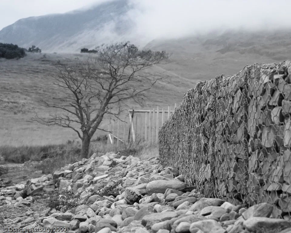
Duncan Astley. Gabions at Loch Hourn, Corran, Scotland
Gabions are transparent to water, but obstruct larger things: sand and rock. A near-perfect solution, water is not thwarted, it comes and goes, but in a diminished way, its force absorbed by the gabion. The fill would be formless and weak if not held in place by the wire cage which, with the lightest of touch, forms a fighting unit of rubble.
Hesco Bastion

German forces filling Hesco bastions in Iraq
Monday, October 4, 2010 at 6:25AM
Jimi Heselden died in 2010 in a Segway scooter accident. He was, according to his obituary notices, the epitome of the entrepreneurial inventor from the gritty side of Leeds. He developed the gabion into an international manufacturing company that provided flat-packing wire and canvas frames that, when filled with sand or gravel or building debris or whatever is at hand, forms a heavy wall against erosion, mortars, bullets, landslides. The R-House is a fortified building: a square of bastions with a heavy canvas top strapped over for a roof: 'living space for six to eight people against the potentially devastating after-effects of any disaster'.
Hesco is divided into humanitarian, civil and military applications with many variations of the basic frame filled with rubble. RAID is a 400m concertina wall packed into a 20' container. It pulls out of the containter, a meter wide and 2.2m high, providing instant cover. The Hesco website it shows a truck shooting down a track the RAID wall flooding out behind it. Once standing it can be filled, or used for storage, but its main use is as an instant forward operating base. It's a terrific concept – fast, effective; thundering music in the little video demo brings home that war needs ideas, and it needs someone to put those ideas in place. Lives depend on them. The Hesco website is full of information and photographs of the most amazing products. Heavily copyrighted, thus no images here. However, when looking up the history of the gabion, I find it is an ancient war defence, once used by Leonardo da Vinci for foundation fortification.
Heselden gave away millions to charity, he bought Segway just last year as the future of personal transportation able to be developed in many different ways. He was on one when it tumbled over a cliff near his home. A freak accident cutting short a canny, clever, generous, visionary life.
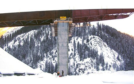
Park Bridge, Golden BC

Park Bridge in construction, 2006. Kicking Horse Canyon, east of Golden, BC
Monday, December 28, 2009 at 8:46AM
One of the most spectacular bridges on the Trans-Canada is the new (2007) Park Bridge on the descent into Golden. Now that it is open you barely know you are on a bridge, so wide and smooth is it, but during the several years of its construction you drove on the old highway underneath it (the highway and the CPR tracks show in the image above). The central piers are about 150 feet high, tall and elegant; from the old highway it was clear we were all going to pitch off into space way up the hill, shoot across the ravine and catch the hill on the other side, bypassing the dangerous twisting old road all together. You can't see any of this now from the new road, it is all just more highway, safe and fast and that marvellous registration of the extreme topography is lost.
Anything under construction is so exciting. It is when concept, theory and practice are all evident to the eye, and the architecture, in its widest sense, is diagrammatic and understandable. Construction workers give the scale, one understands the size of the project. Once it is all done, scale is subsumed by a comfortable opacity, the process of building has become an object, with a function, and we use it unthinkingly.
Placing the girders on the piers
This photo is from the Park Bridge girder launching on the Kicking Horse Canyon highway construction website photo gallery, circa 2009. Alas, these webpages are no longer accessible. One might be able to find them, but I can’t. It’s a shame, as the construction of these massive infrastructure projects are almost more interesting as process, than as product.